(view powerpoint- urban connectivity diagrams)
The site itself consists of 3 different types of edges: Post Oak Road, I10 Highway, and the edges of I610 above. Each edge has varying degrees of permeability.

Studying the site, I divided it into zones: “interstitial” and “along the strand”. As massive as the structure above is, there is a sense of permeability in all directions. The space is incredibly well lit and there is a lot of access to view of the sky.


In looking at the actual edges of the highway and how their perceived, I carried the lines down in even intervals to study how it alters how you inhabit the space. Raising paths into these lines can split them apart, so you can literally inhabit the edge.


However, I am also bringing in the urban grain of the surrounding city. I carried the lines in then shifted them with the grain of the existing highway structure.

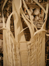
The block is divided into two parts:
housing (slower paced)- follows the grain of the city. Once it is under the highway it slopes into the ground.
artist studios and galleries (quick, ephemeral)- moves with the motion of the highway. Clings to the edge and pulls it open.


The same way engineers construct highways based on radii determined by speed, the form of this architecture would be determined by such factors as well.

Feedback from the review:
The project is about re-centering. Where is the program?
What about tearing down walls? Why not cross to the other side?
Go back to speed and mobility- look at lines pulled down, density areas- where is there less open space? Is that where you would intervene?
Differentiate between where you are in elevation and where you are in plan.
You are moving the center to link either side, but you have to go all the way around- there is a problem with this.
Rates of circles is where the interest is- differences in speed.
Material logic: disconnect between it and mapping meaning. There must be a conceptual rigor or it is nonsensical.
JW- “I am going to use your bridges to bridge different things. That’s a beautiful thing”
There’s another scale that hasn’t been woven in yet.
You are tapping into an existing structure- the live load and dead load are extremely variant. The weight of the freeway has nothing to do with cars.
Build a large model with paths- so everyone can really understand spaces and overlaps.
Watch Paris, Texas for one highway scene.
Relationship to water- cutting section to see those relationships. (Very beautiful set of plans: Cut plans every 5-10 feet to watch your project develop in tandem with highway.
Question materiality- important realization.
is there supposed to be a link to a powerpoint?
ReplyDelete