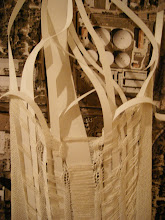
In the beginning I studied relationships in transitional phases from a fabric to a model of a highway. The study was not about the beginning or end, but about the space between. The ends were what seemed unnatural. Throughout the study, there was a constant struggle in mitigating scale and speed- this is also a constant struggle in the city.
This is essentially the core of my project: Designing between, on, around, over, and under the highway and working with it and its neighbors existing systems by:
- Breaking down edges
- Connecting (potentially) across the “river”
- Oozing and flowing loosely through a set structural grid.

Feedback from the review
- Understand loop as tension and diversion. There is an intensity of connections in certain moments THEN an incredible discovery of the underbelly.
- Can we propose new uses for these spaces?
- Cathedral of the 21st Century. Set it up as a stage- anything can happen here.
- Give a new reading to this site. Create an armature to allow different things to happen.
- Floating Cafés
- This is a destination and about moving back and forth across a highway.
- Series of diagrams talking about threshold, filter, subject, designation. A gathering from all sides. Diagram all the scales within and test them out. Diagram the dynamics of urban systems- who is coming here? Water?
- Is it one moment or parallel moments?
- What is on both sides?
- Where are points of gathering?
- There are already flows- how to divert, capture, filter these flows?
- Model- changing forest- urban landscape- how do we navigate through these spaces?
- Think about sound. So much water when it rains. What is a flooded forest? There are certain universals and certain things that are specific to
- Seasonal changes in terms of use
- How do you build off a field or forest?
- Impose methodology- build the thing so we understand its complexity. Series of sectional models.
- Stephen Holl- edge of city project
- How do you decide what to do now? Radius, loops, or outside narratives could start to inform this.
- Forest, flooding ,access to sky—if it were a building, what does it need to do to negotiate neighborhood and forest- a building that’s porous, survives flooding, and allows people movement.
- Gateway into the city- a “rest stop” into city.
- Phenomena of light and dark.
- Observatory- amplifying or reaction to spaces. Be tactile.
- ….Choose a juicy program.
No comments:
Post a Comment