Thursday, May 14, 2009
Wednesday, May 6, 2009
Friday, May 1, 2009
Wednesday, April 29, 2009
Monday, April 27, 2009
Sunday, April 26, 2009
highway manifesto
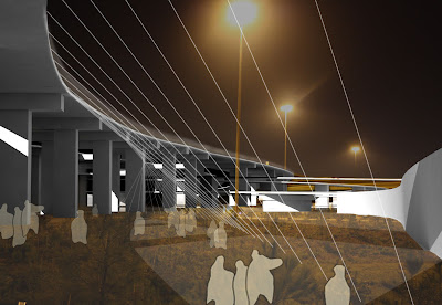
In our modern city there is land that has been taken from its inhabitants, land that has been deprived of the artist, the designer and the performer even though art can exist in the most brutal of spaces. Architectural intervention can be small, piggybacking on the ready-made space, but enough to break misconceptions and glorify the infrastructure as a space-making device. Meanwhile, there is still something absurd about inhabiting this space. With that, Its functions should not be mundane. It is a place to provoke a strange urbanism and to see the world differently. Human imagination is not necessarily limited by the laws of physics or the limitations of modern urban theory. It offers an alternative approach to thinking about cities, how they are formed and how they function.
Much of the city is barred off from the public as it is subdivided and privately owned. However, owned by the city, this space already belongs to the citizen and it is his right to inhabit it. In a environment gasping for breath, it is important to capitalize on the infrastructure that already exists. The highway acts as a barrier within the city. Infiltrating its voids allows the city to redeem an existing architecture to frame relationships between existing urban fabrics. Approximately 30 acres (23 football fields) of unused space lay beneath a raised highway interchange.
Creating a subversive architecture and urbanism that is not just invasive, but traitorous to an existing conception of the life underneath a highway, my project is about acknowledging edges and invading them. Shifting the perception of an edge so that the actual thing becomes permeable and inhabitable. On the site, there are edges between grains/fabrics/textures and my thesis is about breaking down and diluting the edge. When the textures collide, they fuse and transition into one another, creating moments of thresholds and recentering for meaningful exchange. In these instances, the thresholds are often more exciting than space they border. The reclaimed space within the edge allows for flexible, and unscripted inhabitation.
Similar to the flow of the highway above, there are gradients of speeds within the site. The curves of paths are determined by the radii of flow. For example, the shape of a turn intended for the individual is dramatically different from one intended for a crowd.
Scholars can predict the size of cities by their water supply. The Roman aqueducts were the greatest engineering feats of the ancient world, creating massive marks across the landscape. The highway is our urban cathedral. If our culture was to fall as the Romans did, the highway would be what is left behind. Creating a culture of alternative guerilla urbanism will indicate a culture of connectivity, flux, and ephemerality.
EDGES>intersection/transition, circulation
This is done through projecting the edge from above, inserting paths within them in order to expand the edge and move within it.
Similar to the flow of the highway above, there are gradients of speeds within the site. The curves are paths are determined by the radii of flow. For example, the shape of a turn intended for the individual is dramatically different from one intended for a crowd.
Saturday, April 25, 2009
Friday, April 24, 2009
Thursday, April 23, 2009
Wednesday, April 22, 2009
Saturday, April 11, 2009
Thursday Review
(view powerpoint- urban connectivity diagrams)
The site itself consists of 3 different types of edges: Post Oak Road, I10 Highway, and the edges of I610 above. Each edge has varying degrees of permeability.

Studying the site, I divided it into zones: “interstitial” and “along the strand”. As massive as the structure above is, there is a sense of permeability in all directions. The space is incredibly well lit and there is a lot of access to view of the sky.


In looking at the actual edges of the highway and how their perceived, I carried the lines down in even intervals to study how it alters how you inhabit the space. Raising paths into these lines can split them apart, so you can literally inhabit the edge.


However, I am also bringing in the urban grain of the surrounding city. I carried the lines in then shifted them with the grain of the existing highway structure.

The block is divided into two parts:
housing (slower paced)- follows the grain of the city. Once it is under the highway it slopes into the ground.
artist studios and galleries (quick, ephemeral)- moves with the motion of the highway. Clings to the edge and pulls it open.


The same way engineers construct highways based on radii determined by speed, the form of this architecture would be determined by such factors as well.
Feedback from the review:
The project is about re-centering. Where is the program?
What about tearing down walls? Why not cross to the other side?
Go back to speed and mobility- look at lines pulled down, density areas- where is there less open space? Is that where you would intervene?
Differentiate between where you are in elevation and where you are in plan.
You are moving the center to link either side, but you have to go all the way around- there is a problem with this.
Rates of circles is where the interest is- differences in speed.
Material logic: disconnect between it and mapping meaning. There must be a conceptual rigor or it is nonsensical.
JW- “I am going to use your bridges to bridge different things. That’s a beautiful thing”
There’s another scale that hasn’t been woven in yet.
You are tapping into an existing structure- the live load and dead load are extremely variant. The weight of the freeway has nothing to do with cars.
Build a large model with paths- so everyone can really understand spaces and overlaps.
Watch Paris, Texas for one highway scene.
Relationship to water- cutting section to see those relationships. (Very beautiful set of plans: Cut plans every 5-10 feet to watch your project develop in tandem with highway.
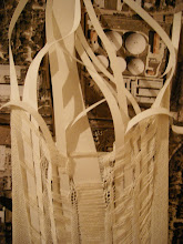
Question materiality- important realization.


